‘Entirely home-grown technology’ used as Chinese marine geologists explore 100km stretch along disputed Scarborough Shoal. Made in China devices not only cheaper but seen as capable of evading technological sanctions as the US and its allies step up containment drive. — SCMP
Chinese researchers have completed a large-scale geological exploration mission near the disputed Scarborough Shoal in the South China Sea.
In a first for such expeditions, all critical devices used were developed and made in China, according to the researchers. This means they were not only cheaper but also immune to potential technological sanctions as the United States and its allies step up their campaign to contain China.
The 45-day mission involved a study of the geophysical structures along a straight 100km (62 mile) line in disputed waters off the eastern coast of the Philippines, a rival claimant to the Scarborough Shoal.
Scientists surveyed as deep as 4,000 metres below sea level for the operation, a joint venture between the Chinese Academy of Sciences’ South China Sea Institute of Oceanology (SCSIO) and the China University of Geosciences (CUG) – both leading research institutes in marine geology.
The team set off on the expedition in early July on board the Shi Yan 6, the newest and one of the most advanced research ships owned by China.
Chinese state media reports on the survey attracted a lot of public attention. But the lead researchers have kept a low profile.
“It was just a normal exploration (voyage),” Sun Zhen, deputy director of the SCSIO’s Key Laboratory of Ocean and Marginal Sea Geology told the Post.
The team used advanced electromagnetic (EM) imaging to arrive at their findings.
“All the transmission and reception equipment used in this voyage were independently developed by Chinese scientists,” Sun said.
“The operation, which took four years of preparation, used entirely home-grown technology, marking a significant stride in a field previously dominated by a few international entities.”
The use of EM signals is a common method to probe geological structures. It is also used to investigate the Earth’s physical structure in the deep seabed, where imaging of the measured EM data can give researchers an idea of the geological structures.
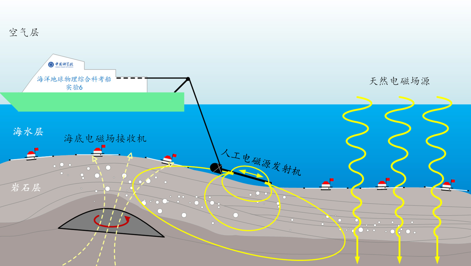
In a 2019 mission in the same area, SCSIO researchers made use of 30 EM receivers placed on the seabed, to collect data in a process called magnetotellurics (MT).
MT is one of two marine geophysical methods used to interpret EM signals, the other being controlled-source electromagnetic (CSEM) surveys.
“This recent expedition augmented the effort with addition of the CSEM method,” a report on the SCSIO website early last week said. “The research team also made significant advancements in EM field observation and data processing, with 34 receivers deployed.”
EM imaging can help to distinguish between fossil fuel, water and rock layers, and can therefore be applied in marine oil and gas exploration, combustible ice detection, reserve estimation, and underground structure imaging.
The older MT is a passive method that makes use of the natural variations in the Earth’s magnetic field. It can give readings from greater depth but its drawbacks include weaker signals, lower accuracy and greater interference.
The CSEM method, in contrast, makes use of artificially created EM signals, with powerful magnetic coils towed across receivers on the seabed while emitting an EM field. This method offers improved accuracy and freedom from interference, albeit with limitations on EM emission power.

“The [latest] project reveals China’s ability to use marine EM methods to detect seabed geological structures and resources,” the SCSIO’s official report said.
Compared with EM surveys on the ground, marine operations carry higher risk and costs. The sea’s absorption of EM waves also poses a challenge.
“Yet, we achieved long-term observation of natural source EM fields in the deep sea, coupled with the successful implication of the CSEM method,” CUG professor Wang Meng said in the official report.
“The high-power artificial EM source effectively supplemented the high-frequency natural source EM signals absorbed by the thick seawater layer.”
The report did not mention any possible military applications. – South China Morning Post


